
Royal Military Canal Towpath Ruckinge to Hamstreet. 80 years of change.
Written by Peter Sillibourne 2026
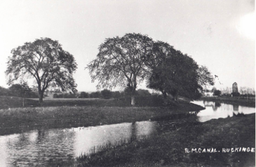
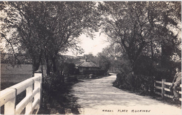
Pictures Pre 1960
In 1807 an Act of Parliament set out the plans and requirements to create The Canal. This necessitated dividing parts of farms, which were on higher ground, into two, leaving them with land south of the canal. A strange anomaly of this Act was that the land owner on the north bank would own the canal bed and the tow path. The tow path was originally a narrow strip of land adjacent to the south canal bank. Boats could be towed along the watercourse.
Before my time, a ditch/fence/trees separated the towpath from the farmers road, along which livestock were driven to the fields on the south side. A picture, taken at Ruckinge Canal bridge facing towards Hamstreet, clearly shows a hedge, the farmers road and the grass towpath along the water’s edge. Date unknown.
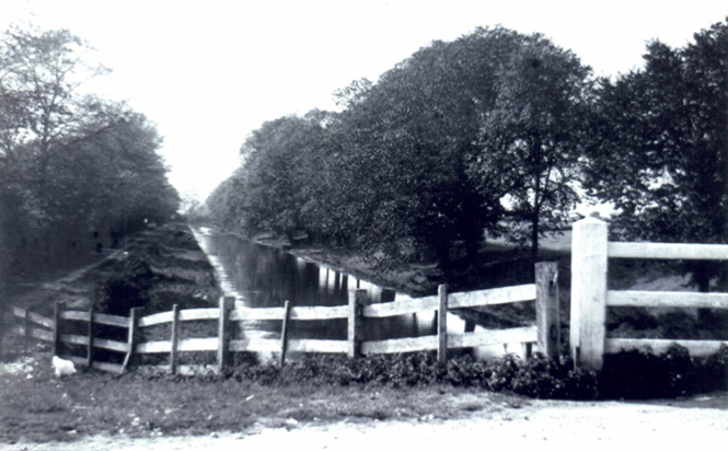
This was filled in and became part of the adjacent field. There were still two access gates, side by side, between fields. They are still visible by the old ruins.
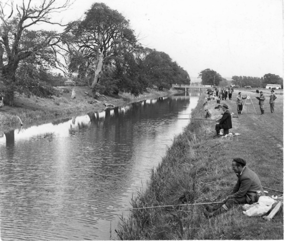
An interesting picture, provided by the Kentish Express, shows fishermen spread evenly along the bank taking part in a competition. During the summer fishing season coaches would bring the fishermen from London at the weekend for a day in the country! The organisers can be seen weighing the catch to establish the winners. These visitors could cause problems for the farmers. The first one walking down the towpath would open the gate, leaving it for the next one to use, and so on down the line. Nobody would take responsibility for closing the gate and livestock would get mixed, or worse still get into the adjacent cornfield. 30 plus fishermen in the country for a long day, with no toilet on the bus, meant the hedgerows could become rather unpleasant.
This picture clearly shows Bridge Cottage and the new canal bridge. The large trees on the north bank are elm trees just starting to die from Dutch elm disease. This puts a date of about 1960 on the picture.
Mr. Desmond Sherwood, our local woodman, from Bromley Green took on the task of clearing these once majestic trees. In 1980 whilst clearing these enormous trees he had an aneurysm and died on the canal bank. He was only fifty-five. His family had to complete the work of measuring the trunks and logging them up so that the timber could be sold to the best advantage with only the small branches going for firewood.
In 1964 change came to the canal bank. The Kent River Authority decided they would try to improve the drainage of about a thousand acres of the marshland in Ruckinge. The estimated cost was £10 thousand pounds.
At the time water had to meander its way along sewers out towards Snargate and then turn back towards a pumping station at Kenardington where it was pumped into the canal. A very long journey and it was weeks before flood water on our marsh fields subsided.
In 1964 the KRA bought a few square yards of land from my father, Stephen Mace Sillibourne, to enable them to build the pumping station adjacent to the canal. The previous year they had negotiated to widen a small ditch to act as a reservoir for the pump. The Kent River Board set about making the towpath hard to enable all the supplies and materials to be got to the site for building to commence. A picture shows the construction of the pump, all below ground level.
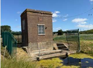
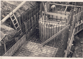
The finished building did not have a very good protective barrier and sheep and hares became drowning casualties. Eventually a substantial fence was erected to protect humans as well.
Also, in 1964 I purchased at auction the land that was farmed by Bert Hickmott of Hampden Farm, Cotton Hill. His access was from Hamstreet Canal Bridge.
The laying of a hard trackway delighted all who wanted to use it. Access was a contentious subject between users as old documents clearly show.
I have a copy of a statement dated 1981 made by Mrs Askew of Upper Sturt, who once lived in Glebe Lodge, the now derelict bungalow (third field in) from Ruckinge. Her father, Mr. Sillwood bought the property and land in 1924 and, together with Harry James, ran a milk round from there delivering milk, eggs and butter to Bilsington, Ruckinge and Hamstreet. They used a horse and cart on the farmers road since Councils’ opinion was that the towpath was only for pedestrian use and the farmers road was open to anyone. Mrs Askew moved with her mother when her father died and they lived at Upper Sturt where her mother married Reg Russell.
Harry continued at Glebe Lodge having sold the goodwill of his business to Bob Collick of Marshside Farm. Harry enjoyed life at his isolated home until his death in 1975. The property is now owned by a local brother and sister.
A hard track opened up the land for tractors to gain access whatever the weather or time of year. Fairly quickly the track was spoilt. Vast quantities of cow manure were dumped alongside the track for storage.
In November 1976 access was blocked by bales and manure and the farmers road had been ploughed. Access for other farmers was therefore on the towpath but the Act of Parliament debarred them from using it. Eventually a compromise was agreed whereby the land users could travel on the towpath and the farmers road could remain as part of the field.
Only the Hamstreet end of the towpath had been a bridleway/footpath, almost as far east as the pumping station, where it met the pre 1807 track that went up through the woods at Gill Lane towards Ashford. In 1970 during a review of the Definitive Map of Public Right of Ways (PROW) it became designated as a byway under the auspice of the PROW. There was frequent dialogue between Southern Water and PROW on the state of the byway. Nobody wanted to take responsibility for its upkeep.
The canal used to be sprayed annually to control the weeds, but this discontinued for fear it was harming nature. Then a large dredger with a cutter bar did the annual weed cutting. The only problem was it did not reach across the whole width of the water. Now, the modern method is to have a boat with a cutter bar underneath that cuts the weed. Another boat then scoops the weed up and deposits it on the bank.
Wildlife was abundant in my early years, but with the unintended release of mink into the countryside moorhens and ducks have an additional constant predator. Life is tougher now and interrupted by humans and dogs as well. Canoeists enjoy paddling on the water.
In 1980 I was the culprit who ruined the grass entrance at Hamstreet. Lorries loaded with turf, during a wet summer, churned the towpath up. The River Authority permitted me to make the track hard. This coincided with the Mid Kent Water Company yard being cleared in Hamstreet ready for house building. They were pleased to have found a local place to get rid of large hardcore.
In 1981 the landlord, of ground along the canal, which originally belonged to Mountain Farm Hamstreet wanted to sell his land. My father, who was the tenant, had to purchase it before selling it on to me, to add to our adjoining land. My father had to make a Statutory Declaration of how he had used the towpath as of right to access the land since 1964 without interruption, or payment to anybody.
The Royal Military Canal Footpath, from Warehorne to Giggers Green, was created following a public enquiry held in Bilsington in February 1997. This opened the north bank from Ruckinge to Bilsington as a footpath and the south bank towards Hamstreet to just beyond the pumping station as an official footpath. Kissing gates were installed for pedestrian use. However, over the years these have been removed to give wider gateways for larger farm machinery.
However, in 1998 tonnes of rubble became available at the site of the Kent Highways Depot at High Halden and it was transported by Bromleys Haulage to the Hamstreet end to make the remainder of the grass towpath hard. The KCC paid for the haulage and my new workman levelled it all with a Matbro.
In 2014 Ruckinge Parish Council requested that the PROW be repaired. After a site visit from a PROW officer from KCC, she said that so long as one could pass along the route that was all that mattered. The ruts were irrelevant. In June 2014 I applied to the Environment Agency on behalf of the RPC to undertake to fill the potholes along the canal path.
In the following six years, with a helper, I applied, by hand, over 350 tonnes of road plannings. The EA paid for 40 tonnes, as did the Romney Marsh Internal Drainage Board. The PROW eventually paid for 35 tonnes. The remainder, plus the cost of doing the work was paid for by my farm to enable good access for vehicles. Unfortunately, motor bikes and 4×4 don’t always respect the trackway.
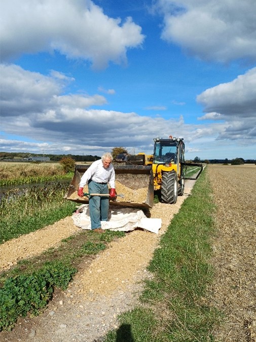
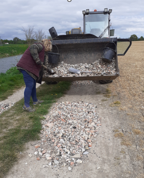
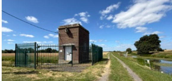
So, from a little used grass track the towpath has evolved into a hard track. The farmland has been improved with drainage and the public have easy access to a beautiful amenity.